I’d known for ages that I’d have the whole Christmas and New Year period off work, so I’d had a while to plan a winter trip to mid Wales. Snow, ice, cold …. would I need my axe and crampons? The Boxing Day freeze gave me hope, but we were back to relatively warm weather by the time I went away a few days later so I left the iron-work at home but I still took my winter sleeping bag, spare warm clothes, candles, two torches, firelighters, and my Kindle (for reading by headtorch during the long winter evenings).
I reverted to my trusty old Karrimor Jaguar 65 rucksack – although I am now doubting whether it does actually have 19 litres more usable space than my Osprey Exos 46. The rucksack was rammed full and blooming heavy. I didn’t weigh it until I got home [as I didn’t want to put myself off before I’d left the house] but it weighed about 15kg – which is getting on for 3kg more than I take on the TGO Challenge. It was heavy, and it felt heavy.
Starting from Aberystwyth, I got the bus to somewhere I couldn’t pronounce then followed a road towards the Teifi Pools. The OS map shows that the road peters out and I was not sure how far the hard surface would continue. The combination of short days and long train journies meant that I needed the navigation to be easy so that I didn’t get lost in the dark.
I’d heard that there were Red Kites in the a rea, so was pleased to see a couple flying relatively low and close enough for me to get a photo. No, it’s not the best quality wild-life photo but it was better than I expected!
The 1:50,000 OS map does not show any sort of path or track going to Claerddu bothy. I’d read that there is a track, but I didn’t know where it started, so my plan was to use my GPS to do the final 500m of navigation. It was now after 4pm and getting quite dark, so I turned on my GPS while I still had enough light to compare my current position with the bothy’s grid reference. Oh bother! The (nearly dead) batteries which had worked OK in the warm at home were struggling with the cold and would not power up the GPS. My spares were in my pack and I didn’t want to waste the precious fading light by stopping [yes, I did have a torch with fully functioning batteries in my pocket!] so I resorted to good old-fashioned compass bearings and map reading. After a few minutes tramping over rough ground I found a decent track which went roughly North. By now there was hardly any daylight left and I told myself that I would have to stop and dig out my spare batteries if I’d not found the bothy in the next five minutes.
I was on the verge of dropping my pack when I turned a bend and the shadowy outline of a building came into view. As there were no other buildings marked on the map this had to be it. Expecting to have to ford the river I was pleased to find a stone slab bridge and arrived, dryshod, at the bothy just before 5pm. There was nobody at home.
Only a few years ago, I would have been terrified at the thought of walking to a bothy in the middle of nowhere, in the dark, with the intention of spending the night on my own or, worse, with the Axe Murderers and psychopaths who are well-known to frequent such places. Maybe I’ve just been lucky and not had a bad bothy experience but I don’t seem to be frightened of them anymore.
Claerddu bothy is maintained by the Elan Valley Trust and is a palace in comparison with many others. There are sleeping platforms in the two upstairs and one of the downstairs rooms. There is bottled gas to the two ring burner, water on tap and a flush toilet in the lean-to outside. Unfortunately the wood store was empty so I could not fire up the stove – but I certainly won’t be leaving negative comments on TripAdvisor!
 I had the bothy to myself all night and, after dinner and a couple of hours of reading, turned in quite early. The grafitti and the comments in the bothy book suggest that this is a well-used bothy, so I did wonder if I may get company later on, but most of the usual visitors seem to be D of E and other youth groups and I doubt they plan many expeds for the day before New Year’s Eve.
My plan for day 2 was to take a leisurely wander to Moel Prysgau bothy (MBA). It took me until 10 o’clock to finally get packed up and on the way. I watched a very healthy-looking fox striding down the track while I brushed my teeth. Whether he’d seen me or not, I don’t know, but he certainly wasn’t bothered by my being there.
The Teifi Pools did not appear to be the same shape, or in the same positions, as marked on the OS map so I’m not exactly sure what route I took. I was following a track at first but it wasn’t consistent and I generally just headed South regardless of what was underfoot.
If I were to take one lesson away from this trip it would be that the tracks, bridleways and footpaths marked on OS Landranger 147 are figments of someone’s imagination. Maybe they used to be there but have faded? Maybe new ones have taken priority and not yet been added to the map? Some started off OK, then dumped me in the middle of nowhere. Some re-appeared when I had given up all hope. I know that my estimation of distance is poor, and I was not using my GPS for most of the day, so some of the errors may have been mine but I found it very easy to be in not quite the place I thought I should be.
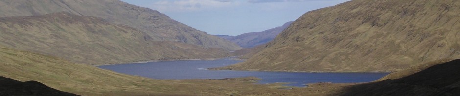
The surrounding countryside, in places, reminded me of the Monadhliath in its bleakness.
 But there were also plenty of hills and valleys and signs of how the countryside has been worked over the years.
 I assumed that this ruin was Garreglwyd, which meant I then wandered off along a fork in the path which didn’t exist. Garreglwyd turned out to be the group of buildings at least half a km further along the track.
 The toughest part of the day was the next mile of tussocky bog going South towards the forest. I soon lost the bridleway and did not find it again until I’d almost reached the forest. Imagine very long thick grass which has got so sodden that it has flopped over into huge soft piles which look like they would take your weight but which, when you stand on them, suck you downwards into mid-shin deep water. Imagine a mile of that. It was hard work. The long grass also wrapped itself round my boots and became snagged in my gaiter buckles; providing a constant anchor in case I should consider breaking into a jog.
The area is popular with 4-Wheel-Drive enthusiasts – it still has Byways Open to All Traffic, which have been reclassified to exclude motorised vehicles in many parts of the country – and I had seen 2 pairs of Land Rovers slowly driving the green lanes. Many years ago, I was a keen “laner” (not an “off-roader”, these are roads) and I thought back to how much fun I’d had spending Sundays exploring the ancient roads and byways of the Peak District and North Wales. My point of view has changed a little as I’ve got older. If I was still a “green laner” then I like to think I’d be joining work parties to keep the roads in good condition as there’s no doubt that a two tonne vehicle has the potential to do a lot more damage than even a large group of walkers….. although walkers cause a lot of erosion in some areas.
Two Land Rovers had followed the road, through the ford, into the forest. My plan was to go a little further, avoiding the ford, and take the bridleway through the forest. This should take me straight to the bothy – although I was having trouble making out all of the detail on the crowded OS map. Anyway, my intentions soon came to nothing as I could not find the bridleway. The forest had no obvious gap and a fairly recently replaced fence may have obscured any previous entrance into the forest. Mindful of the many times I have sworn NEVER to take a shortcut through a forest, I retraced my steps and found the least wet way across the water-course and back onto the hard track.
I didn’t expect to be able to see the bothy from the track but nor did I know when I would need to change direction and head into the trees. When my compass told me I was now heading North I realised that I must have missed my turning and I wondered if the remnant of fence post with a large rock on top (ie makeshift cairn) which I had passed 150 metres ago may have been the path I needed? I turned round and, almost immediately, saw the edge of a roof down below near the river. The short walk through the forest was dark and gloomy but it gave me the opportunity to collect a few fallen branches. I was determined to have a fire tonight.
From this direction I was approaching the bothy from the rear and it didn’t look particularly welcoming as it stood damp and dank in the fading light but, round the front, I found the (bi-lingual) MBA sign and felt relieved that I’d found it and I still had enough daylight to make myself at home before night fell.
The stove had been swept out and relaid with dry kindling and I soon had a modest fire going. I couldn’t resist taking a photo which (if you look closely) shows wisps of smoke coming from the chimney.
 The MBA has done a lot of work in this bothy over the last few years. The roof has been completely replaced and “The Snug” has been removed and then replaced – presumably now in line with fire regulations. The snug makes a huge difference to the warmth of the bothy as the heat from the stove is trapped in a smaller low-ceilinged room. The height of the outer room goes right up to the roof and would take a LOT of heat to even take the chill off.
Previous visitors had prepared a lot of wood and there was even a small amount of coal so I spent rather a long time reminding myself of the practical skill of lighting – and maintaining – a fire. At first I seemed to be making more smoke than flame but once I’d got some bigger logs burning the heat levels went up and the smoke cleared. It was taking so long to get the stove hot that I actually cooked my dinner on my gas stove, but I let it simmer and made my after dinner cup of tea on the bothy stove. A cold December night in Rowchoish bothy a few years ago had taught me just how much wood you can burn if you want to fend off the cold all night and I did not want to selfishly use up all of the wood that someone else has kindly prepared for me.
By 8 o’clock I’d had my tea and was snuggled up reading the bothy book with thoughts of letting the stove burn out and going to bed. The book showed that the Maintenance Organisers had spent a couple of days there over the last few days and that the bothy was usually inhabited on New Year’s Eve. Convinced that nobody would be daft enough to try and find this place in the dark, I was slightly startled to see flashes of bright light through the window…. [to be continued]

Interesting account Judith, looking forward to the next instalment
LikeLike
One of the best reads of the new year so far, I am also looking forward to part two.
LikeLike
Its a great area to backpack and be away from the crowd. Wet underfoot in places, but enjoyable walking I found.
LikeLike
Hi Martin. It was very wet underfoot – and that’s the only thing that would put me off going back. I wore my Sealskinz socks on one day and, as usual, they let me down. In the summer I don’t mind wet feet as much but, in the winter, they can be very unpleasant. The remoteness was excellent, though.
LikeLike
Sounds like a good first half of an adventure.
Have a look and compare the route you did on a 1:50k map with the same area on a 1:25k map. Some of those wrong turns and paths to nowhere may start to make more sense!
What I’ve done in the past if nav might be tricky is to produce my own laminated map of the route / area with 1:50k on one side and 1:25k on the other; always a full spare map in the sack.
Looking forward to part 2. Bringing back fond memories of a new years eve spent in Dulyn bothy!
LikeLike
Hi Simon. Yes, the 1:25k map does show some useful detail. If only I had thought to print off a few sections before I left home! I think of Dulyn bothy as “my” bothy as I joined a work party there a few years ago. I’ve heard it’s been vandalised recently but I’ve not been back to see how bad the damage is.
LikeLike
Haven’t been to Dulyn for at least 10 years now – long overdue for a return trip.
That being said, these Mid Wales ones have been on the agenda for a long time to visit – 2015 is possibly the year to do it.
Hope part 2 has more pics… 🙂
LikeLike
“The long grass also wrapped itself round my boots and became snagged in my gaiter buckles; providing a constant anchor in case I should consider breaking into a jog.”
That made me giggle!
And on to the next part!
-)
LikeLike
Hi,id like to tey this bothy as ive been to a few in midwales but not this one.need the grid reference for it
LikeLike
Hi. Just really enjoyed reading your post. I live just south of here and passed through recently ticking off another section of the Cambrian Way. I can certainly relate to how hard tracking down those paths in the forestry is.
LikeLike
Pingback: Charles Hawes: The Cambrian Way from Pontrhydfendigaid to Cwmystwyth